The Parliamentary Constituencies Order 2023
The Privy Council has now considered and on 15th November approved the Order in Council with regard to the new parliamentary constituency boundary recommendations. The Order can be found here.
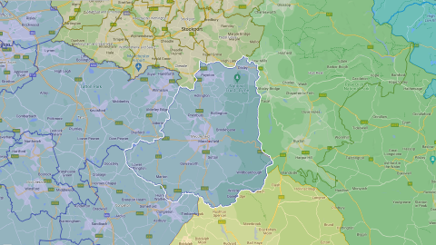
We concluded the 2023 Review with submission of our final report and recommendations on 27 June 2023. Access the final report and data via the 2023 Review link above. To view an interactive map of the recommended new constituencies, go to:
Information about the review of Parliamentary constituencies in England that concluded on 27 June 2023.

Recent news and developments from the Boundary Commission for England.

Downloads and links for the detailed statistical and mapping data published or used by the BCE in its work.

Information about the status and structure of the Commission, including corporate and biographical details.
The Privy Council has now considered and on 15th November approved the Order in Council with regard to the new parliamentary constituency boundary recommendations. The Order can be found here.
Read full press release here. The Boundary Commission for England has today published its final recommendations for new constituency boundaries. This follows submission of its final recommendations report to the Speaker of the House of Commons yesterday, and that report now being laid before Parliament. The Commission has now fulfilled …
The Boundary Commission for England has today submitted its report containing final recommendations for new constituency boundaries to the Speaker of the House of Commons. In doing so, the Commission has fulfilled its statutory responsibility, and submission of the report ends the Commission’s involvement in the 2023 Boundary Review. The …
We are pleased to confirm that we are on track to submit our final recommendations report for new Parliamentary constituency boundaries to the Speaker of the House of Commons by the deadline of 1 July 2023. It’s likely we will submit our final recommendations around the end of June 2023. …